Navigation Wonder is no longer supported
Navigation Wonder v.1.5
Version 1.5 is mainly a bug fix release and it fixes a lot of irritating small errors, and it has a few cosmetic changes.
NAVIGATION-WONDER is a Windows based
GPS Navigation program.
It allows you to navigate in real-time, and to pinpoint your position in realtime on any digital map. Use your own maps, for example from the Internet, scan your own paper maps and charts, Roadmaps, ityplan, Capture maps from Routeplanners, Aviationmaps etc... However, a GPS-Receiver has to be connected to the serial port of your Laptop / PC.Minimum System Requirements
Windows 95/98/2000/ME/XP
Pentium. 32 Mb Ram.
GPS Receiver
soundcardIn order to use NAVIGATION-WONDER you DON'T have to program your GPS receiver.
Just connect it to your computer (please use our wiring instructions, only two wires)
and NAVIGATION-WONDER will take care of the rest!
ROUTE-SAVING
A trace can be left where you have driven, sailed or flown. If you wish, you
can store your route to harddisk.
You can store as many routes per map on your harddisk as you wish.
USE YOUR OWN MAPS!
NAVIGATION-WONDER allows you to use your own maps: for example,
Internet, scan your own paper maps and charts, Roadmaps, Cityplan,
Capture maps from Routeplanners, Aviationmaps etc... However, a
GPS-Receiver has to be connected to the serial port of your Laptop / PC.
You can use maps with different scales The possibilities are 'boundless'
( please always first read the copyright conditions before you start scanning a map )
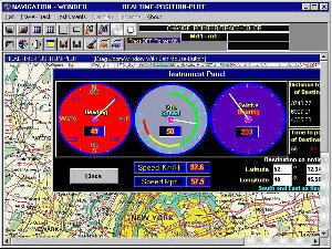
ADF: Automatic Direction Finder / INSTRUMENT PANEL
Continuous relative bearing to your point of destination.
Continuous distance indication to your point of destination.
Continuous "time to go indication" to your point of destination.
It is possible to activate an instrument panel from which you can readout
your actual Direction, Speed and Bearing.
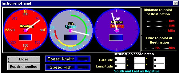
This is a screenshot of the instrument panel
MAP-ZOOM (1 level)
Map-Zoom: you can project an extra little zoom-window on the digital map.
The section of the map where you are momentarily is then enlarged.
You can also move (drag) the zoom-window with the left-mouse button.
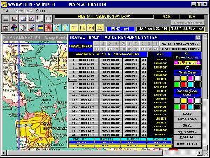
MAP-CALIBRATION
A Map-Calibration program is also included so you can calibrate
your own maps so that they are ready for use with NAVIGATION-WONDER
Realtime-Position-Plot.
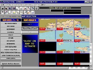
AUTOMATIC MAP SWITCHING
NAVIGATION-WONDER works with a fine and easy to use interface.
the right map of the area where you are is automatically selected.
By crossing a mapborder the next map is automatically loaded.
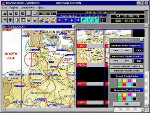
MAP-SIMULATION
There is also a Map-Simulation program included, so you have the
ability to entirety simulate your route and to test the maps you have added
and calibrated with the map-calibration program.
POSITION-LOCATOR
Enter the co-ordinates of the position you whish to see on the digital map,
and NAVIGATION-WONDER will show you that point on the map.
DISTANCE CALCULATOR
Enter the coordinates of two locations, and NAVIGATION-WONDER will
calculate the exact distance between these two locations.
(available in MAP-SIMULATION)
THE AVIATION - HEADING/GROUNDSPEED CALCULATOR
This function is very useful for ( Private ) Pilots.
Calculating a Navigation-Plan is very easy with this utility
VOICE-RESPONSE
It is possible to activate voice-response. You are then
directed to your destination. (turn left/turn right/ arrived)
You need to configure this yourself.
GPS Monitor
This program allows you to monitor the GPS-output on your screen and save it to disk.
MAPS INCLUDED
There are some simple overviewmaps included.
©1998 - 2003 WingWay systems