GPS Direction Finder
(Palm OS Software) Freeware
Before you start using GPS Direction Finder, please read the section IMPORTANT in this manual!
What's new in version 1.0.4b?
Ģ The NMEA parsing routine has been completely rewritten. As a result, Direction Finder is capable to operate with almost every GPS receiver.
Ģ Color added.
System requirements
Ģ Minimum Palm OS: version 4.0
Ģ GPS receiver.
Program size on Palm
117 Kb.Features
Ģ Real-time direction indication by means of an analog instrument.
Ģ VERY accurate!
Ģ Constant reading of distance, bearing and time to your point of destination.
Ģ Store hundreds of waypoints! (if you wish) and activate a waypoint with only one tap.
Ģ No maps needed.
Ģ You don't have to program your GPS receiver. You simply enter the waypoints in your Palm,
not your GPS receiver, and GPS direction finder will take care of the rest.
Download
What is GPS Direction Finder?
GPS Direction Finder is capable to guide you real-time to your point of destination. You will only need to enter the geographical coordinates. However, a GPS-receiver should be connected to your Palm device. GPS Direction Finder is very accurate, it will give you a constant distance and time reading to your point of destination. It will also show you an instrument panel with a needle. This needle is constantly pointing to your (you guessed it...) point of destination. Also known as an aviation ADF (automatic direction finder). The main advantage of GPS Direction Finder is, that you don't need any maps, only the coordinates of your point of destination!
Will it work with my GPS receiver?
As long as your GPS receiver is capable of producing NMEA RMC sentences, it should work correct.
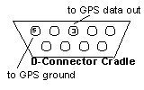
How to connect a GPS receiver to your Palm device?
Please use our wiring instructions as described below. Also, don't forget to configure your GPS receiver for NMEA. It is a good idea to consult the manual of your GPS receiver. You use your cradle for communication with the GPS receiver. Your Palm should stay in the cradle during real-time navigation. Wiring is simple. Connect your GPS receiver to your Palm or compatible device with only 2 wires. Connect the "data-out" of the GPS receiver to pin (entrance) 3 of the cradle, and connect the "ground" of the GPS-receiver to pin (entrance) 5 of the cradle.
layout of the Cradle D-Connector.
Tip: You could use a small piece of tape to keep the Palm sit in the cradle during traveling.
Installing GPS direction Finder on your Palm.
The first time you must install the files:
Ģ gps.prc
Ģ wayp_cdb.pdb
Ģ mathlib.prc
MathLib
MathLib is a free shared library that can be used by any at least OS 2.0 Palm program that needs IEEE 754 double precision math functions. It's distributed under the terms of the GNU General Public License, and is freely available with full source code and documentation at the MathLib Information web page. It's not a part of the GPS Direction Finder, and you are not paying anything for its use. A copy is simply included in this archive for your convenience. For more information on MathLib, see the MathLib webpage at http://www.probe.net/~rhuebner/mathlib.html
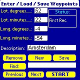
Entering and selecting Waypoints
Before you start, you must select a waypoint. This is easy. If you start GPS Direction Finder you'll see the Waypoint- screen. This is where you enter, save and select the waypoints. GPS direction finder is capable of storing hundreds of waypoints!
keyfield:
If you are searching in the database for a waypoint, then the "description field" is the keyfield! So, enter your waypoint(s) in geographical coordinates, give a description and don't forget to save.
Top
IMPORTANT!
Please keep in mind that you enter Southern latitudes, and Eastern longitudes as negative numbers and Northern latitudes and Western longitudes as positive numbers! As you can see below, we entered a waypoint called "Amsterdam". Latitude ( Both Degrees AND Minutes ) has been entered as a positive value. Longitude ( Both Degrees AND Minutes ) has been entered as a negative value.
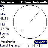
Start Realtime Navigating
After you have saved your waypoint(s) it's time to select a waypoint for realtime GPS navigation. Simply tap the start button. This will bring up de instrumentpanel with the distance, bearing and time readings. If the Needle appears, then the program is recognizing your GPS receiver properly. Now follow the needle until you are at your point of destination.
Legal
GPS direction finder version 1.0.4b is released as Freeware. GPS direction finder version 1.0.4b is owned by WingWay systems. You may not sell, reverse engineer, decompile or disassemble GPS direction finder version 1.0.4b In no event will WingWay systems be held liable for any loss, expenses, or damages of any kind whatsoever, whether direct, indirect, incidental, or consequential, arising from the design, or use of GPS direction finder version 1.0.4b.